Introduction
On May 22, 2025, the European Space Agency (ESA) announced a significant milestone in geospatial science with the launch of the Atomic Clock Ensemble in Space (ACES) mission, now operational on the International Space Station (ISS). ACES, a highly precise atomic clock system, promises to redefine how we measure elevations on Earth by leveraging the principles of Einstein’s general relativity. The most frequently asked problem worldwide in this context is the inconsistency in global elevation measurements, which leads to costly errors in construction, navigation, and environmental monitoring. This blog explores the challenges of achieving accurate elevation data and how ACES provides a transformative solution, potentially establishing a unified global standard for elevation measurement.
The Problem: Inconsistent Elevation Measurements Worldwide
Elevation measurement is a cornerstone of modern science and engineering, impacting everything from infrastructure development to climate change studies. However, inconsistencies in how elevations are measured globally pose a significant challenge, as highlighted by a historical incident in 2003 when German and Swiss engineers building a bridge over the Rhine River discovered a 54-centimeter discrepancy due to differing sea level references. This problem persists today, affecting various sectors and raising questions about precision and standardization.
1.Discrepancies in Sea Level References
The concept of \”sea level\” is often used as a baseline for elevation, but Earth’s seas are not uniform. Variations in gravitational pull, ocean currents, and regional differences mean that sea levels can differ by tens of centimeters between locations. For instance, the North Sea and Mediterranean Sea, used as references by the German and Swiss engineers, differed by 27 centimeters, leading to the bridge misalignment. Globally, this lack of a unified zero point for elevation creates inconsistencies, making it difficult to compare measurements across regions and leading to errors in large-scale projects like bridges, tunnels, and dams.
2.Limitations of Current Measurement Techniques
Traditional methods for measuring elevation, such as ground-based surveying and plane-based gravimetry, are labor-intensive and costly. These techniques rely on physical measurements of the Earth’s gravitational field to create a geoid, a model representing the planet’s gravitational equipotential surface. However, these methods achieve precision only at the decimeter level, which is insufficient for applications requiring centimeter or sub-centimeter accuracy, such as precision agriculture, flood modeling, and urban planning. The high cost and logistical complexity of these methods also make them impractical for widespread global use.
3.Impact on Navigation and Space Exploration
Inconsistent elevation data affects more than just terrestrial projects, it also complicates navigation and space exploration.GPS satellites, which rely on atomic clocks to measure distances, must account for gravitational time dilation as described by Einstein’s general relativity.Clocks at higher elevations tick faster due to weaker gravity, introducing errors if not corrected precisely.Current GPS clocks, while accurate, lose a second every 3,000 years, translating to positional errors of about 30 centimeters per nanosecond of timing error. For deep space missions, where precise navigation is critical, these errors can mean missing a target like Mars by hundreds of miles, underscoring the need for more precise timekeeping.
4. Challenges in Establishing a Global Standard
In 2015, the International Association of Geodesy adopted the International Height Reference Frame (IHRF) to standardize elevation measurements worldwide.However, a decade later, the system still struggles with precision and adoption.Geodesists aim for centimeter-level accuracy to support applications like sea level rise monitoring and tectonic movement studies, but existing clock networks and geoid models fall short.This global challenge has led to calls for a more precise, space-based solution to unify elevation measurements and reduce errors across continents.

The Solution: ACES and the Power of Space-Based Atomic Clocks
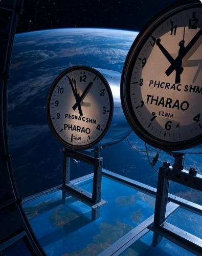
The ACES mission, launched by the ESA and now operational on the ISS as of May 2025, offers a revolutionary approach to solving these elevation measurement challenges.By combining two atomic clocks – one using cesium atoms (PHARAO) and the other using hydrogen (SHM)—ACES achieves unprecedented precision, losing only one second in 300 million years Here’s how ACES addresses the global problem of inconsistent elevation measurements.
1. Creating a Unified Global Clock Network
ACES links its space-based clocks with the most accurate ground-based atomic clocks worldwide, forming a synchronized network. This network leverages optical and microwave technology to compare time signals with a precision of 10 centimeters in elevation—far surpassing current methods. By measuring the gravitational time dilation effect, where clocks tick faster at higher altitudes, ACES can map geopotential differences across the Earth. This data will refine the global geoid model, providing a consistent zero point for elevation measurements and eliminating discrepancies caused by regional sea level variations.
2. Enhancing Precision with Relativistic Geodesy
ACES utilizes the principles of relativistic geodesy, a science that measures the Earth’s shape and gravitational field using time dilation. According to Einstein’s general relativity, a clock at a higher elevation (weaker gravity) ticks faster than one at sea level (stronger gravity). ACES, positioned 400 km above Earth on the ISS, can detect these minute differences in time with unprecedented accuracy. Geodesists can use these measurements to validate and improve the geoid model, achieving the desired centimeter-level precision. This precision is crucial for applications like monitoring sea level rise, where even small errors can skew long-term predictions.
3. Reducing Costs and Improving Accessibility
Unlike traditional surveying methods, which require extensive fieldwork, ACES offers a cost-effective alternative by operating from space. The mission’s ability to connect with ground-based clocks via laser ranging stations, such as those in Europe, allows for global coverage without the need for on-site measurements. This scalability makes it feasible to update the IHRF and extend its adoption worldwide, ensuring that even developing regions can benefit from precise elevation data. The cost savings and accessibility of this approach could democratize geospatial science, enabling more countries to participate in global initiatives like climate monitoring and disaster preparedness.
4. Supporting Navigation and Fundamental Physics
Beyond elevation measurement, ACES enhances navigation for both terrestrial and space applications. By providing a more precise timekeeping standard, it reduces errors in GPS and future navigation systems, improving positional accuracy to within centimeters. For space exploration, ACES paves the way for autonomous navigation, where spacecraft can determine their position without constant communication with Earth – a critical advancement for missions to Mars and beyond. Additionally, ACES will test fundamental physics, such as gravitational time dilation and the search for dark matter, offering insights that could further refine our understanding of the Earth’s gravitational field.
5. Prototyping a Future Global Network
ACES is a prototype for a broader vision: a global network of space-based atomic clocks. While ACES achieves 10-centimeter precision, future iterations could reach sub-centimeter accuracy, fulfilling the goals of geodesists worldwide. This network would enable real-time monitoring of geopotential changes, such as those caused by tectonic shifts or melting ice caps, providing invaluable data for climate science. By demonstrating the feasibility of space-based clock networks, ACES sets the stage for a new era of geospatial measurement, where elevation data is consistent, precise, and universally accessible.
Challenges and Future Outlook
While ACES is a significant step forward, challenges remain. The mission’s two-year duration limits the amount of data it can collect, and scaling up to a permanent clock network will require international collaboration and funding. Privacy concerns may also arise, as precise elevation data could be used for military purposes, necessitating careful governance. However, the potential benefits—improved infrastructure, better navigation, and enhanced climate modeling—far outweigh these hurdles. As ACES completes its commissioning phase in late 2025, its findings will likely spur further investment in space-based geodesy, bringing us closer to a unified global elevation standard.
Conclusion
The launch of the Atomic Clock Ensemble in Space on May 22, 2025, marks a turning point in addressing the global challenge of inconsistent elevation measurements. By leveraging the precision of atomic clocks and the principles of relativistic geodesy, ACES offers a solution that unifies elevation data, reduces costs, and enhances applications from navigation to climate science. As this mission unfolds, it not only solves a pressing geospatial problem but also opens new frontiers in fundamental physics, proving that the future of measurement lies in the stars. With ACES leading the way, we are on the cusp of a new era where elevation is no longer a source of error but a tool for global progress.


